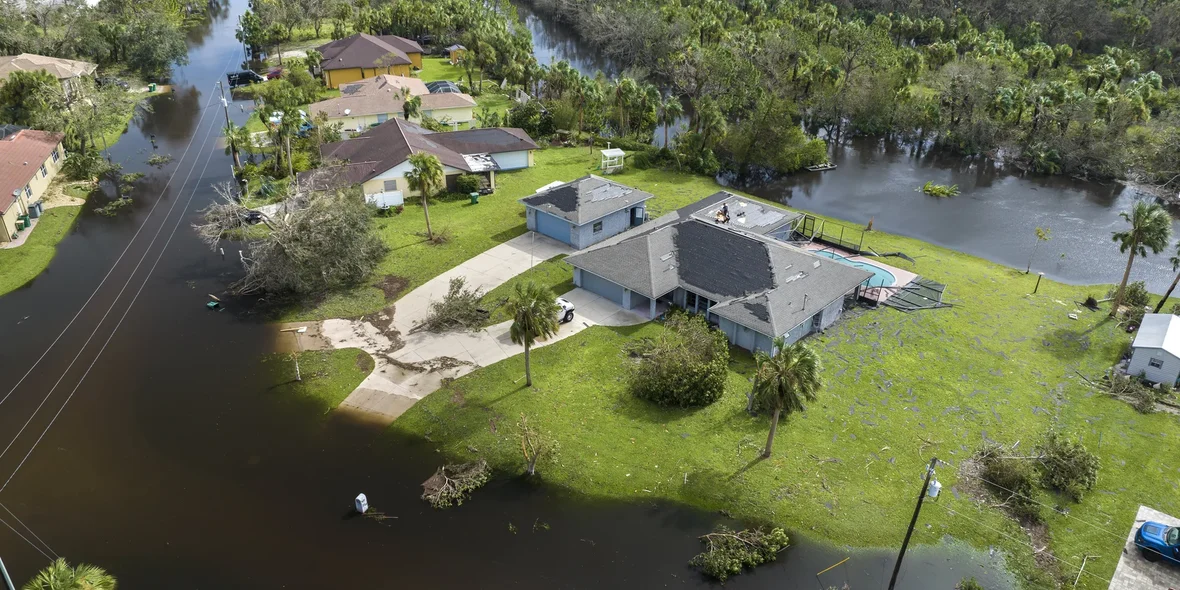
Buying a Home in a Flood Zone: What You Need to Know Before Purchasing Real Estate
Floods and local flash flooding have become more common. Many U.S. states report a growing number of water-damage claims, and potential flood-risk areas are expanding faster than official risk maps are being updated.
According to estimates from the First Street Foundation, 14.6 million homes in the United States are already in an area with substantial flood risk. This is about 6 million more than what is shown on FEMA maps. Data from the Federal Reserve Bank of New York indicates that up to 75% of high-risk properties are completely missing from current FEMA maps.
This means that even when buying a new home, you may discover that it is located in a risk zone, and it is better if this becomes clear immediately rather than during an actual flood. In this material, we will look at why homes in such areas can sometimes be financially attractive and what you need to ask the seller before purchasing.
What a Flood Zone Is
A flood zone is an area where the probability of river overflow or accumulation of surface runoff is higher than the average level for that region. The U.S. system uses several classifications, but two are critical for buyers:
- Special Flood Hazard Areas (SFHA). These are areas with a one-percent annual chance of flooding. Over a standard 30-year mortgage period, the chance of experiencing a major flood reaches 30 percent. Zone A represents the highest inland risks and usually includes areas near rivers and lakes. Zone V covers coastal areas exposed to storm waves and structural damage caused by water impact.
- Moderate-to-Low Risk Zones (Zones B, C, X). They are formally considered low-risk, yet statistics show that about 20 to 25 percent of flood insurance claims come from these areas. The reasons include weak drainage systems, intense local rainfall, and the lack of protective engineering infrastructure.
FEMA maps are updated slowly. In some counties, the latest updates were published more than ten years ago. During this time, rainfall levels and hurricane intensity have increased, and actual flood patterns may have changed without being reflected in official documents. As a result, a home may be formally outside an SFHA but in practice located in an area that floods repeatedly.
You can quickly check the status of a property through:
- FEMA Flood Map Service Center. It helps identify the zone by address and shows the estimated flood elevation.
- Elevation Certificate. This document confirms the true position of the house relative to the projected flood level and often affects insurance costs.
- Insurance reports. Databases that record past insurance claims, similar to CLUE, can show how many flood-related claims were filed for a specific address.
- Municipal surface-runoff maps. Many cities publish separate maps that show the risk of stormwater flooding, which FEMA does not include.
Pros and Cons of Buying a Home in a Flood Zone
Buying a home in a flood zone does not always mean purchasing a problematic property. Such homes can be attractive in terms of price and location, although they require a more thorough inspection to understand the potential cost of future repairs.
Pros of Buying a Home in a Flood Zone:
- More affordable price. In many U.S. markets, homes in high-risk areas sell for about 3 to 8 percent less. If there is a history of flooding, the discount can reach 10 to 15 percent.
- High-demand locations. Some risk zones include coastal regions, riverfront lots, and areas with desirable views.
- Opportunity to lower insurance payments. If the home sits above the calculated flood elevation or has modern protective systems installed, insurance premiums can sometimes be reduced by agreement with the insurer.
- Potential for price growth. When a municipality upgrades stormwater systems, reinforces levees, or implements major water-management projects, the area may gradually move out of the high-risk category and increase in value.
Cons of Buying a Home in a Flood Zone:
- Higher insurance costs. For homes in high-risk zones, annual insurance premiums may exceed 2,000 to 4,000 dollars. If the property has already received insurance payouts, premiums can reach 7,000 to 10,000 dollars.
- Lower resale liquidity. Even with good condition and modernization, demand for these homes tends to be below average.
- Higher maintenance expenses. Even without flooding, owners often pay for servicing drainage pumps, maintaining backflow valves, and clearing stormwater channels on the property.
- Risk of property damage. Even with upgrades, severe hurricanes can cause extensive damage not only to the home itself but also to other structures and items on the lot.
Questions You Need to Ask Before Buying
Even within the same flood zone, the level of risk for two neighboring homes can differ several times over. Factors that affect this include foundation elevation, soil type, the slope and profile of the lot, the state of drainage systems, and the property’s history of damage. This is why, before buying, you need to examine not only the official zoning status but also the actual water behavior on that specific lot and the engineering characteristics of the home.
Which Exact Risk Zone is the Home in?
The first step is to review additional sources of flood risk that are not included in federal maps. For example, federal data reflect only riverine flooding, while many incidents occur due to stormwater runoff, overloaded channels, or local water surges that FEMA does not record.
A buyer needs to find out:
- The exact zone where the home is located (A, AE, V, X, and others).
- When the map for this area was last updated, in some counties it had not been reviewed for 10 to 15 years.
- Whether the map reflects changes in topography, development, and drainage system improvements.
- Whether there are discrepancies between federal maps and independent platforms, such as the First Street Foundation Flood Factor.
If any of these elements are outdated or missing, it is worth using independent models such as Flood Factor along with municipal stormwater-flooding maps.
If risks are present, you should obtain an Elevation Certificate. This document shows how high the home is located relative to the expected flood level. Even in a high-risk zone, a house may be positioned above the projected water elevation, which can reduce insurance costs.
Does the Home have a History of Damage from Natural Events?
The damage history shows what actually happened to the home, even if the official zone status or its maps are outdated. If a specific home has already experienced water damage, this reveals local flood behavior much more accurately than any map.
It is important to learn the exact dates and type of damage, whether the cause was river overflow, a failed stormwater system, groundwater, or something else. You also need to clarify:
- What repairs were carried out. Request documentation rather than verbal assurances. Flood-related repairs should have receipts, contractor reports, photo records, and, ideally, an inspector’s conclusion.
- Whether the home appears in insurance databases for water damage. In the United States, such cases are recorded in reports similar to CLUE. Even one claim increases insurance costs, and several claims indicate recurring events.
- Whether the neighborhood has systemic issues. This is essential for homes that have not suffered themselves but are located in problematic areas. An example is a street where water rises during every second or third heavy rain. These neighborhoods often have lower prices, and if the discount reaches 5 to 10 percent, repeated flooding is very likely.
In several U.S. states, sellers are legally required to disclose past flooding. In others, they may provide only minimal details or omit information if no insurance claim was filed. You should not rely on a seller’s honesty and should verify their statements independently.
Is Separate Flood Insurance Required?
Unlike standard homeowners' insurance, damage from river flooding, stormwater events, and water overflow is not included in a basic policy. In the United States, it is covered either by a separate policy under the National Flood Insurance Program (NFIP) or by private insurers.
The first step is to determine whether a flood policy is required by law or under mortgage conditions. If the home is in a high-risk zone (A, AE, or V), mortgage lenders almost always require coverage. Even if the property is in Zone X, where insurance is officially optional, lenders tend to prefer borrowers who have it.
You should also consider that private insurers may offer more favorable pricing, especially when the home is situated above the projected flood level, although they may refuse coverage for homes in areas with frequent flooding. This can serve as a useful indicator: if an insurance company declines to insure the property, there is clearly a problem with the area.
What Engineering Protection Measures Does the Home Have?
In a high-risk zone, the real vulnerability of a home depends on how well it is protected from water. Engineering solutions can reduce the likelihood of damage several times over.
The key points to check first:
- The elevation of the home. The primary document here is the Elevation Certificate. It shows how high the foundation and major structural elements are positioned relative to the projected flood level. A difference of even 30 to 60 centimeters can reduce potential losses by tens of thousands of dollars.
- Whether the home has mechanisms that prevent flooding. It is important to check if backflow valves are installed on sewer lines and whether there are pressure-relief valves for water. Without these valves, water from an overloaded sewer system can enter the basement or first floor even without external flooding.
- Whether an active water-removal system is present. A home in a risk zone should have functioning sump pumps and backup power sources because power outages during floods are common.
- The foundation structure. Homes built on piles or columns withstand floods more effectively. If the house has a basement, you need to look for signs of previous flooding, such as musty odor, traces of mold, or water lines on concrete walls.
- The materials used in interior finishing. In high-risk zones, builders use ceramic tile, cement boards, and closed-cell insulation that does not deteriorate when exposed to water, unlike drywall or particleboard.
Even if the home is formally in a high-risk zone, strong engineering protection can make it safe. Without such measures, even properties in moderate-risk zones can be more vulnerable to flooding.
What Protective Measures Exist in the Surrounding Area?
Flood risk also depends on the ability of the neighborhood to manage excess water. Even excellent protection at the individual property level is not enough if local infrastructure is overloaded, levees are aging, and stormwater systems have not been serviced for years. This is why you need to assess conditions at the neighborhood level before buying:
- Which engineering structures protect the area from water. You need to check whether the county has levees, canals, controlled reservoirs, pumping stations, and flood-control gates.
- When these structures were last serviced. Some levees in the United States have not undergone full modernization for 10 to 20 years, which makes them unreliable during extreme rainfall.
- How the city’s stormwater drainage functions. An overloaded stormwater system is one of the main causes of unexpected residential flooding. Signs of problems include frequent resident complaints about flooded streets and storm drains overflowing, even during moderate rain.
- Whether there is an infrastructure upgrade program. Some cities invest every year in expanding stormwater systems, replacing street collectors, and cleaning drainage lines. Information about such projects can be found in the capital-improvement plan.
- The topography of the area. Lots located in low-lying zones are prone to water accumulation, especially if the neighborhood sits in a natural basin. You can check elevation using municipal maps or topographic visualization services.
The simplest thing you can do is to look at how the area behaved during past floods. If flooding were a one-time event, the risk would be lower. If it has occurred repeatedly, the neighborhood should be considered chronically vulnerable to flooding.
Documents You Should Request From the Seller
When buying a home in a flood zone, reviewing documentation is just as important as the physical inspection. Documents help determine whether the home was actually vulnerable, what repair work was completed, how accurate the official risk maps are, and what the seller may be downplaying. Here is what you should request:
- Elevation certificate. As noted earlier, this document shows the actual position of the home relative to the potential flood level. It indicates whether the foundation is above or below the projected elevation that water reaches during a flood. If the document is missing, it is better to order an independent assessment before purchasing.
- Flood history. In states where sellers must disclose past flooding, you should obtain the full document. In other states, the seller may provide information voluntarily. The report shows the dates of flooding and the scale of the damage. A lack of data should be concerning only if there are visible signs that flooding has occurred.
- Insurance reports. Even a single insurance claim is an important indicator. You need to determine whether any claims were filed through the NFIP and whether the home was classified as a property with repeated losses.
- Documents related to attempts to revise the flood-zone classification (LOMA/LOMR). If the previous owner tried to change the property’s classification, it is important to know whether the attempt succeeded. If it failed, you need to understand the grounds on which the revision was denied.
- Inspection materials from independent specialists. Sellers sometimes hire engineers to evaluate the home’s condition after a flood or before listing it. If no reports are available, the buyer should order an independent inspection.
Specifics of Buying Homes in Flood Zones in Different Countries
Although most open data and publicly available risk maps are based on U.S. sources such as FEMA, NFIP, and the First Street Foundation, approaches to assessing and managing flood risk vary significantly from country to country. In the European Union, the Floods Directive requires that maps be updated every six years.
Examples of reporting practices in different countries:
- United Kingdom. The Environment Agency publishes separate maps for river flooding, surface-water flooding, and coastal threats. Insurance is regulated through the Flood Re scheme, which makes policies in high-risk zones more affordable.
- Germany. Hochwassergefahrenkarte maps show not only flood zones but also water depth and scenarios of rare and extreme flooding.
- Italy. Risk is often linked to small rivers and aging drainage infrastructure. Some studies indicate a price reduction of about 3 to 5 percent in areas with recurring floods.
- Japan. The country operates one of the most advanced early warning and mapping systems, including tsunami and flood simulations.
- South Korea. Risk zones are revised after each major rainy season. Cities actively implement multi-level drainage systems.
- Southeast Asia. In countries such as Vietnam, Thailand, and Malaysia, flood maps are updated less regularly, which leads buyers to rely more on local residents’ experience than on official documents.
- Australia. Municipalities are required to publish Flood Study Reports and Flood Risk Management Plans. Updates occur more often than in the United States, but there is no central authority, and the same city may have three independent maps for different types of threats.
Summary
Buying a home in a flood zone requires careful preparation. The risk is not theoretical; it affects insurance costs, potential repairs, price dynamics, and the complexity of local infrastructure. This is why you need to verify the actual zoning status, review the flood history, obtain the full set of documents, evaluate engineering protection, and understand how the neighborhood handles water during peak loads.
At the same time, a flood zone does not automatically make a property a poor choice. Homes in such areas often sell at a discount, occupy desirable locations, and maintain stable market value after proper upgrades.
If you plan expenses for protective measures in advance, calculate insurance costs accurately, review documentation, and confirm the reliability of local infrastructure, you can acquire a home that is not only more affordable but also resilient when properly maintained.
Author

I write informative articles about real estate, investments, job opportunities, taxes, etc.